

IMD warns of heavy rain, thunderstorms across southern and eastern India; temperature dip likely in north |


As October nears its end, several regions of India are bracing for an active spell of weather, with the India Meteorological Department (IMD) forecasting widespread rain, thunderstorms, and gusty winds across large parts of the country. The period between October 24 and 29 is expected to witness a series of moderate to heavy showers, with some areas likely to experience very heavy rainfall. Meanwhile, the northern states are set to see a dip in minimum temperatures by up to 5 degrees Celsius, signaling the gradual onset of winter.
South peninsular India to witness active rainfall
The southern peninsula is expected to remain under the influence of multiple weather systems, resulting in light to moderate rainfall and thunderstorms at several locations over the next few days. The IMD has predicted isolated heavy to very heavy rainfall across parts of Tamil Nadu, Kerala, Karnataka, Andhra Pradesh, and Telangana through the week.Tamil Nadu, Puducherry, and Karaikal are likely to receive heavy rainfall on October 24 and again between October 26 and 28, coinciding with the northeast monsoon’s early activity phase. Kerala and Mahe will also see bouts of heavy rainfall, especially on October 27 and 29, with very heavy rainfall expected on October 24. Karnataka, both in its coastal and interior regions, will witness intermittent showers through the week. North Interior Karnataka will see rainfall until October 25, while south interior Karnataka may experience isolated very heavy rainfall on October 24.Coastal Andhra Pradesh, Yanam, and Rayalaseema are set to experience heavy to very heavy rainfall between October 24 and 29, with a peak intensity expected on October 27 and 28. Telangana is forecast to get heavy showers on October 24, 25, and 29, accompanied by thunderstorms and lightning.The IMD has also warned of thunderstorms with lightning and gusty winds across the region for the next five days, advising residents and farmers to take necessary precautions against potential flash floods and localised waterlogging. Coastal areas, including Kerala, Karnataka, and south Andhra Pradesh, are under alert for squally weather conditions with wind speeds reaching up to 55 kmph.
Heavy rain and thunderstorms over east, central, and west India
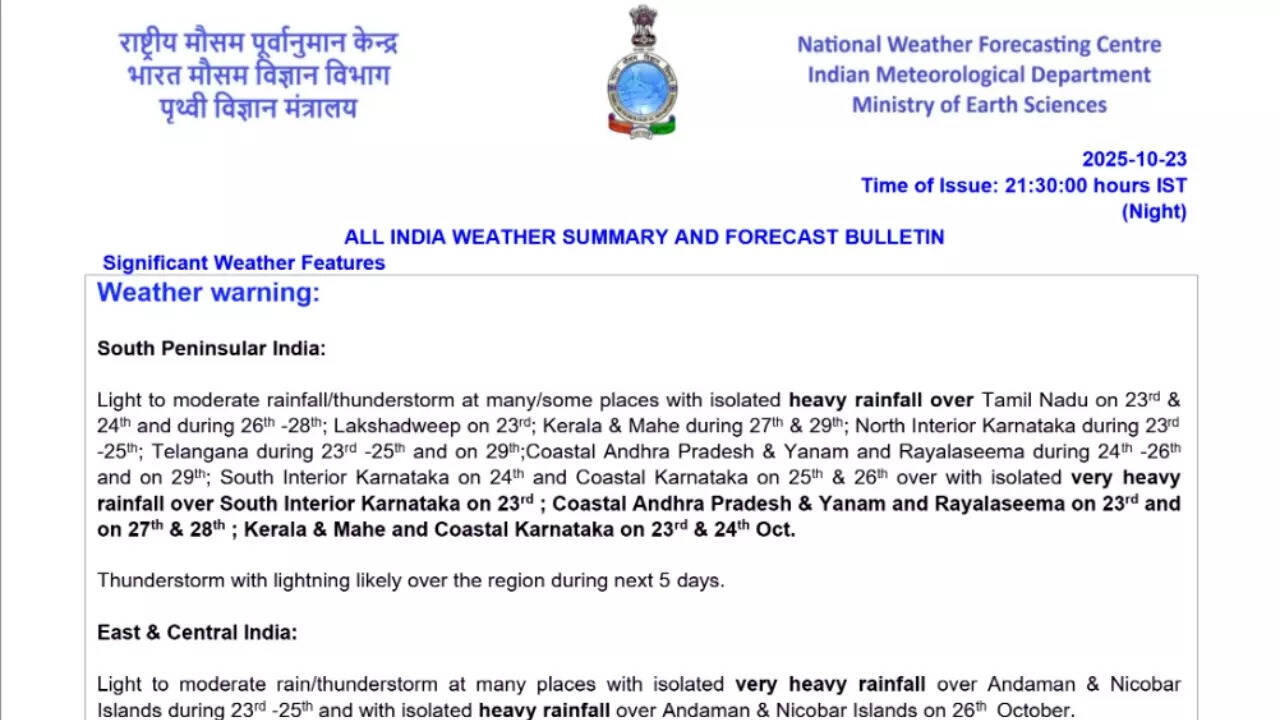
The East and Central Indian regions will also see wet days, primarily because of the weather disturbances over the Bay of Bengal. The Andaman and Nicobar Islands are expected to experience very heavy rainfall on October 24 and 25, with isolated heavy showers continuing on October 26. The IMD has also warned against thunderstorms with lightning and gusty winds (30–40 kmph) over the islands and Odisha for the next five days. Parts of East Madhya Pradesh, Vidarbha, and Chhattisgarh will see thunderstorms accompanied by lightning.The western states are expected to have a wet spell, with Konkan, Goa, parts of Maharashtra, and Gujarat likely to receive scattered rainfall and thunderstorms over the coming days. According to the forecast, Konkan & Goa and parts of central Maharashtra may see isolated heavy rainfall on October 24. Gujarat Region, Saurashtra, and Kutch could experience heavy rainfall between October 25 and 26, accompanied by thunderstorms and lightning. Thunderstorms are also likely over Marathwada and central Maharashtra through the week.Coastal regions of western India, including south Gujarat, Goa, and the Konkan belt, will face squally winds, potentially disrupting marine operations. Fishermen have been advised to stay away from deep-sea areas in the Arabian Sea and Bay of Bengal, where wind speeds may reach 65 kmph in isolated pockets.
Cooler nights for north India
While southern and coastal states brace for rain, North India is expected to experience a noticeable decline in nighttime temperatures. The IMD has forecast a fall in minimum temperatures by 2 degrees Celsius across most parts of Northwest India during the next two to three days. In east Uttar Pradesh, temperatures may drop even further by 3 degrees Celsius to 5 degrees Celsius, marking the transition toward cooler autumn conditions.
Day-wise weather forecast
October 24: Heavy to very heavy rainfall is likely over Andaman & Nicobar Islands, Coastal Karnataka, Kerala & Mahe, and isolated heavy showers over Andhra Pradesh, Telangana, Tamil Nadu, and parts of Maharashtra. Thunderstorms with lightning and gusty winds (30–50 kmph) are expected across southern and eastern regions. Squally winds (up to 55 kmph) will prevail along the Kerala, Karnataka, and south Konkan coasts, extending over the Bay of Bengal and Arabian Sea.October 25: Very heavy rain is forecast over the Andaman & Nicobar Islands, while heavy rainfall is expected over Andhra Pradesh, Coastal Karnataka, Gujarat, and Telangana. Thunderstorms and lightning will persist over interior Karnataka and Odisha.October 26: Heavy rainfall will affect Andaman and Nicobar, Coastal Karnataka, Tamil Nadu, and parts of Gujarat, while isolated thunderstorms will cover Odisha, Telangana, and Maharashtra. Those residing in the coastal regions, and island areas, are advised to stay cautious as strong winds are expected. .October 27–28: By 27th, very heavy rainfall is expected to shift to Andhra Pradesh, Kerala, and Tamil Nadu, where isolated areas could see very heavy downpours. The IMD anticipates moderate to heavy rain at several places. However, the rainfall intensity is expected to reduce after this, by October 29.October 29: Scattered rainfall will persist over Andhra Pradesh, Kerala, and Telangana, marking the tail end of this active weather phase.